What
comes to mind when you hear the word “map”?
You might picture a globe or a paper road map. Maybe you think of GPS on your phone. But, do you ever hear "map" and think GIS?
You might picture a globe or a paper road map. Maybe you think of GPS on your phone. But, do you ever hear "map" and think GIS?
GIS,
or Geographic Information Systems, let us see, ask about, examine, and understand data - especially relationships and patterns in the data. (Learn more about GIS here). GIS can be utilized by
educators to teach and learn. They are interactive, informational, and can be
accessed virtually anywhere.
The
North Carolina Office of
Environmental Education and Public Affairs is putting GIS to good use. In this GIS blog
series, we are going to teach you to use our GIS features, to discover benefits for GIS both in the formal classroom and informal settings, and to explore the
topics that our GIS maps and apps cover: river basins, environmental education
resources, and your ecological address.
So, what is a
river basin?
A river basin is the land that water flows across or under on its way to a river. Just as a bathtub catches all the water that falls within its sides, a river basin sends all the water falling on the surrounding land into a central river. From there, it goes out to the sea.
Everyone lives in a river basin, even if you don't live near the water. The land that we live on eventually drains to a river or estuary or lake, and our actions on that land affect water quality and quantity far downstream. The topography of each basin determines where it drains to. For North Carolina, the water flows into either the Atlantic Ocean or the Gulf of Mexico.
To help you explore your river basin and all the river basins in N.C., we created nineteen (!) GIS features:
1. One App (aka – an interactive map)
2. Eighteen Story Maps (aka – an interactive text)
Let’s start with the app: North Carolina River Basins. I recommend clicking the link or photo below to follow along in our GIS app. You can also access this on our website by going to Resources > River Basin Program > River Basin App.

When you open the app, you are greeted by a welcome screen with some background info, a disclaimer, and information about how to use the app.
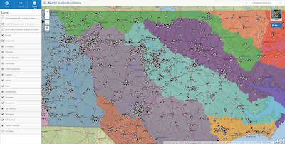
Zooming in, we see there are three icons in the upper left blue bar: About, Legend, and Layers.
About is pretty self-explanatory: learn more here.
You probably remember that a legend on a map is where all the information about represented features are compiled (rivers are blue lines, etc). So, for our river basin app, we see all of the river basins are color-coded to match with their location on the map.
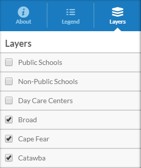
Layers might be new to you. Layers allow you to choose what you see on the map (and what shows up in the legend). In our layers, some are unchecked – so these are not currently in the map view or on our legend. But, if you check the box for public schools…
…then that layer appears on the map. Easy enough.
But - what do these icons on the map mean?
It’s well and good you can see these things on the map, but part of what makes an app great is that it is interactive. The legend tells us that the black and white icons are public schools – but what else can we learn? There are a couple ways to find out more:
1.) Click on the map feature you want to know more about
This pops up a box that gives you tons of info as well as links to other material. For our public schools, we learn its name, address, total number of students and teachers, type of school, and highest grade level.

But, what if you meant to select the river basin layer– not the public school?
Just hit the arrow on the right of the top bar (outlined in red) to view the other features you selected. The numbers in parentheses in the upper-left of the box will let you know how many pages you selected (ex., 1 of 3).

Use the skills we just went over - select what you wish to know more about! Want to learn about the river basin for Raleigh? Just click it.

A river basin is the land that water flows across or under on its way to a river. Just as a bathtub catches all the water that falls within its sides, a river basin sends all the water falling on the surrounding land into a central river. From there, it goes out to the sea.
 |
| Source: http://sageography.myschoolstuff.co.za |
Everyone lives in a river basin, even if you don't live near the water. The land that we live on eventually drains to a river or estuary or lake, and our actions on that land affect water quality and quantity far downstream. The topography of each basin determines where it drains to. For North Carolina, the water flows into either the Atlantic Ocean or the Gulf of Mexico.
To help you explore your river basin and all the river basins in N.C., we created nineteen (!) GIS features:
1. One App (aka – an interactive map)
2. Eighteen Story Maps (aka – an interactive text)
Let’s start with the app: North Carolina River Basins. I recommend clicking the link or photo below to follow along in our GIS app. You can also access this on our website by going to Resources > River Basin Program > River Basin App.
When you open the app, you are greeted by a welcome screen with some background info, a disclaimer, and information about how to use the app.
Zooming in, we see there are three icons in the upper left blue bar: About, Legend, and Layers.
About is pretty self-explanatory: learn more here.
You probably remember that a legend on a map is where all the information about represented features are compiled (rivers are blue lines, etc). So, for our river basin app, we see all of the river basins are color-coded to match with their location on the map.
Layers might be new to you. Layers allow you to choose what you see on the map (and what shows up in the legend). In our layers, some are unchecked – so these are not currently in the map view or on our legend. But, if you check the box for public schools…
…then that layer appears on the map. Easy enough.
But - what do these icons on the map mean?
It’s well and good you can see these things on the map, but part of what makes an app great is that it is interactive. The legend tells us that the black and white icons are public schools – but what else can we learn? There are a couple ways to find out more:
1.) Click on the map feature you want to know more about
This pops up a box that gives you tons of info as well as links to other material. For our public schools, we learn its name, address, total number of students and teachers, type of school, and highest grade level.

But, what if you meant to select the river basin layer– not the public school?
Just hit the arrow on the right of the top bar (outlined in red) to view the other features you selected. The numbers in parentheses in the upper-left of the box will let you know how many pages you selected (ex., 1 of 3).
2.) Search in the search bar
This one is easier. Type in what you want to find in the search bar in the upper right of the screen and a box pops up for that feature.

You may be thinking: But… this is a river basin app. Where is the river basin-specific information?
Use the skills we just went over - select what you wish to know more about! Want to learn about the river basin for Raleigh? Just click it.

Within the
box, you can select the photo to access our river basin brochures that have a
ton of info about each basin’s history, ecology, recreation activities, and
more!
Still want to learn more about river basins? Check out our Discover North Carolina's River Basins story map. This
interactive-text will give you a good overview of basin basics. All you need to
do is click through!


We also have seventeen other Story Maps that talk about each N.C. river basin in-depth. Find them all - from Broad to Yadkin-PeeDee - here!
Remember, when it doubt - click it out. The best way to get familiar with a GIS feature is to use it! So, make some time to learn about the GIS app and discover how you can utilize it to learn and teach about N.C. river basins.
-----
To learn more about our GIS resources, contact the Office or visit our GIS page.
To find out about other things the Office of Environmental Education and Public
Affairs does, check out our website,
Facebook, or Twitter.